Areas of San Francisco Bay Area at risk from sea level rise. Graphic courtesy Arizona State University/Manoochehr Shirzaei)
A new study suggests official flood risk plans for the San Francisco Bay Area may underestimate inundation due to sea level rise over the next century by nearly 4 to 91 percent.
Other coastal cities could face similar effects, even under best-case scenarios.
Photo by Sandra Leander, Arizona State University.
Researchers have finished the first full genome map of the threatened Mojave desert tortoise (Gopherus agassizii), also known as Agassiz’s desert tortoise.
They hope their findings will inform conservation efforts, improve understanding of its evolutionary past and potentially contribute to human medicine.
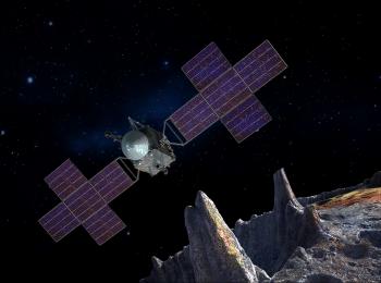
Image courtesy Space Systems Loral/Arizona State University/Peter Rubin
NASA’s mission to 16 Psyche, the solar system’s only known iron-nickel asteroid, will launch in the summer of 2022, one year earlier than originally planned.
Image courtesy Arizona State University / Malin Space Science Systems
NASA plans to send a new, light-sensitive camera to explore the moon’s most shadowed regions. ShadowCam will look for evidence of water ice in the permanently shadowed regions of the moon.
Lunar areas that never receive sunlight – frigid craters and mountain shadows – could conceal a treasure trove of water ice, especially near the poles.
A sacred site built in southwest Colorado around 800 years ago hints that the ancestral Pueblo people might have used geometry.
The analysis of the Sun Temple at Mesa Verde National Park offers the first hard evidence that a prehistoric North American society possibly employed such figures in construction.